
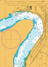
Survey Data Processing


Over the decades, IIC Technologies has been providing marine charting services and solutions for both government and industry. With a global reach and a reputation for superior client service, IIC Technologies is a trusted supplier to over two dozen mapping and charting agencies. Certified by Bureau Veritas, we adhere to strict quality assurance procedures and precise product specifications and standards.
Our team operates as a virtual extension to hydrographic offices, offering a series of services typically found in a hydrographic data value chain. From base survey processing to final product validation and maintenance, IIC Technologies enables hydrographic offices to maximize the use of their own resources to increase productivity and reduce bottlenecks.
We use latest survey techniques and seabed mapping solutions like
Use of such latest techniques helps deliver high quality, timely and cost effective solutions. IIC Technologies always strives to keep base with changing technologies to meet the demand of hydrographic community


 Survey Data Processing
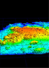
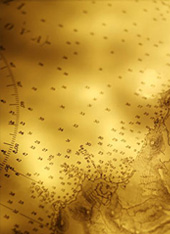
IIC Technologies offers a full range of survey processing solutions and has successfully completed a wide variety of projects for both naval and national hydrographic offices. Our services include data post-processing, surface modeling, sounding selection and contour interpolation. For raw data, IIC Technologies use various software packages to apply biases, suppress beams, and select bin values, depth limits and resolution. The resulting Digital Terrain Model (DTM) is used to produce a specified surface, from which contours can be interpolated and soundings selected. To process dense data from echo sounder, side scan and LiDAR systems, IIC chooses powerful workflow tools including those published by CARIS, IVS, ESRI, Autodesk and Bentley.
POST PROCESSING
Processing raw datasets can be both complicated and time consuming. IIC Technologies experienced technicians use leading edge systems and proprietary routines to accurately and effectively process data captured during survey operations. IIC Technologies derives clean and fully validated results, ready for use with a variety of end products. Regardless of size or complexity, IIC Technologies can manage datasets from all types of sensors, including single beam, multi beam, side scan and LiDAR. Based on the platform, IIC Technologies incorporates vessel geometry and offsets, selects bin values, depth limits and resolution, grids the soundings, applies filters and biases, suppresses beams, and adjusts for sound velocity, tide and squat. Cleaning the soundings requires either a manual process (swath or 3D) or advanced automated filters based on Total Propagated Uncertainty (TPU) and Combined Uncertainty and Bathymetry Estimator (CUBE). To ensure the best quality standards, IIC Technologies performs vigorous QC throughout.
SURFACEMODELLING AND SOUNDING SELECTION
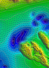
Once raw bathymetric data has been properly cleaned, validated and accepted, IIC utilizes the data for navigation surface modeling, contour interpolation and sounding selection. Creating a base surface requires the careful application of detailed parameters, including surface resolution and node computation algorithms. To interpolate contours, IIC must first generalize the high density soundings by creating a product level surface suitable for the specific end product. For final contour interpolation and sounding selection, a variety of constraints are considered, including product scale, printed vs. digital format, unique bottom characteristics and product purpose. The output from the processing routines is then interactively reviewed and the required cartographic adjustments made. For verification, IIC compares the new soundings and contours against the previously p ublished paper charts and ENCs. Satellite or aerial imagery, overlaid on the final DTMs, can also be used for verification.
SYSTEMS AND SOFTWARE

To effectively process raw datasets and the resulting Digital Terrain Models, IIC needs powerful tools provided a number of software suppliers. While IIC can work with virtually any software program, we typically use Fledermaus, CARIS HIPS/SIPS, Starfix.Proc, Starfix.Nav and Coda GeoSurvey for our raw data processing. For sounding selection, contour interpolati on and surface modeling, IIC uses CARIS BDB, Composer, AutoCAD Map, ArcGIS, ArcInfo, ArcView, and MicroStation. Other popular production line tools include Hypack, Kongsberg SIS, Surfer, etc. No matter what the system, IIC can process data and deliver products in virtually any format.
Navigation Products
IIC Technologies assist the world’s leading hydrographic agencies with a wide variety of digital production services. From the compilation of paper charts to the creation of ENCs, DNCs and AMLs, IIC Technologies combine years of experience with an unsurpassed capability in digital hydrographic data. The company helps clients by augmenting their existing workflow, relieving the pressure on resources and increasing efficiency and productivity.
Paper Charts
Balancing clarity with detail, IIC provides professional paper chart compilation services with a range of workflow options. Our knowledge of national and IHO chart standards allows us to implement specifications seamlessly, producing charts from various analog and digital sources. Qualified and trusted, IIC’s team of experienced cartographers includes former hydrographic office staff expertly trained in chart compilation. We have successfully completed over a dozen complex compilation projects for numerous hydrographic offices.
ENCs, IENCs and DNCs
A well-known expert in the S-57 and VPF standards, IIC Technologies has delivered thousands of ENCs, IENCs and DNCs to hydrographic agencies around the world. Consequently, IIC Technologies has developed innovative production routines that both maximize efficiency and maintain quality. IIC Technologies’ broad experience with various product specifications and standards is second to none. IIC Technologies works closely with clients to address all their requirements, providing full production, validation and maintenance solutions.
Raster Charts
Following the creation of digital paper chart files, IIC exports the resulting datasets to one of a variety of raster data formats.Depending on the requirement, the final rasters may be used in ECS or ECDISsystems or other GIS platforms. Outputs include BSB, HCRF, KMZ, TIF, GeoTIF, JPG2000, and GeoPDF.
AMLs, TODs and MIOs
Since 2003, IIC has been supplying tactical charts to support naval operations and improve situational awareness. A producer of Additional Military Layers (AMLs) and Tactical Ocean Data (TOD), IIC has secure facilities with strict protocols to safeguard sensitive information. IIC has also been active in the development of Marine Information Overlays (MIOs), including the conversion of sailing directions to S-57. From time-sensitive and mission critical layers to the integration of sailing directions and coast pilots, IIC has extensive experience with the capture and integration of MIOs.
Field Sheets and Fair Charts
IIC Technologies continues to digitize and capture a wide variety of historical field sheets, fair charts andsmooth sheets. Before digitization and feature capture begins, sheets are rectified, referenced andshifted to WGS84. Vector feature extraction may include the capture of soundings, line work, rocks and bottom quality information. Final deliverables include quality control reports that list any anomalies.
Hydrographic Database Services
Today's hydrographic database systems eliminate redundancy and increase efficiency but the strain on existing resources can be high. IIC Technologies assists hydrographic agencies with database creation, data loading, and product generation. Working remotely, via Citrix connectivity, IIC Technologies can prepare, assess and harmonize your source data, saving you time and expensive effort. Plus, IIC Technologies can generate paper charts, raster charts and ENCs from your database, accelerating production timelines and chart availability. Throughout, we ensure that client data remains safe and never leaves your server. IIC continues to work closely with many large hydrographic agencies to skilfully deliver multiple database projects.
Validation & Maintenance
The validation and continual maintenance of chart products are crucial requirements of every hydrographic program. IIC Technologies has unrivalled experience delivering continual maintenance and incremental updating services. IIC Technologies can acquire and apply critical and non-critical updates, including NTMs, List of Lights, and new hydrographic and topographic surveys. IIC then formats, processes and deconflicts the sources prior to compilation into ENCs and paper charts.
For validation and verification, IIC Technologies ensures that newly produced chart products comply with all applicable national and international specifications and verifies that the cartographic content of each chart matches the original sources. Charts are examined for completeness, positional accuracy, correct coding and attribution, and functionality. Both manual inspection and software routines are used to detect problems.