Safety
Home
Aerial Surveys

Aerial Surveys
IIC Technologies possesses Cessna Grand Caravan 208 B Aircraft, fully modified to undertake Aerial Surveys using high resolution imagery and LiDAR technologies. IIC Technologies has Intergraph DMC II 230 large format digital mapping camera and Leica ALS70 airborne LiDAR sensor. Possession of these aerial assets, enables us to provide end-to-end services in Terrestrial solutions using aerial technologies and topographic mapping. Our qualified and experienced geomatics experts ensure that our clients receive the very best in aerial surveying. With experience over years our team of experts can assist in flight planning and photo acquisition, LiDAR acquisition and processing, processing of satellite imagery, photogrammetric scanning, groundtruth collection, and high precision photogrammetric mapping.
To complete the full circle of services IIC Technologies offers complementary services such as seamless orthophoto generation, digital terrain / elevation models, 3-D visualization, volumetric calculations, and GIS/data conversion and translation.
Aerial Surveys
Services
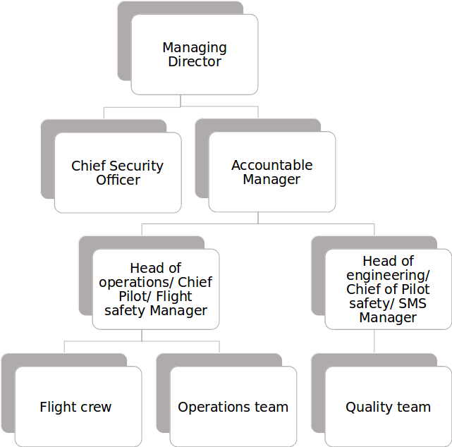
Organogram
Contact Us
Safety

IMPORTANT PASSENGER INSTRUCTIONS
- Children whose age is between 2 to 12 years will be allotted separate seat.
- Unaccompanied minors between age group of 5-12 are permitted to travel onboard IIC Technologies Aircraft and will be provided with assistance. Crew will be informed about them.
- Infants below two years are allowed to sit on lap of Passenger accompanying them. Extension of Seat Belts will be provided by IIC Technologies limited.
- IIC Technologies Limited will not refuse to carry persons with disability or reduced mobility and their assistive aids/devices, escorts and guide dogs including their presence in the cabin.
- It shall be the responsibility of the persons with disability or reduced mobility to notify their needs at least 48 hours before the scheduled time of departure so that the IIC Technologies Limited will make necessary arrangements,
Which may include but not limited to the following:
- Nature and level of special assistance required while embarking, disembarking and during in-flight;
- Mobility equipment and assistive devices that need to be carried by the airline either in cabin and/or aircraft hold;
- Requirement of escort
For embarkation/disembarkation and in-flight use, IIC Technologies Limited aircraft is not certified to carry on board aisle wheelchairs for persons with disability or reduced mobility.
IIC Technologies Limited aircraft is not certified to carry passengers in a stretcher or incubator.
Non -ambulatory persons with disability or reduced mobility will be permitted to travel in a single flight when such passengers are accompanied by trained escorts.
Services
Aerial Survey, Photogrammetry and Mapping Services:
IIC Technologies provides end-to-end solutions for most advanced aerial survey, Photogrammetry and Mapping services. Products generated from these services are used for Town planning, Engineering purposes including infrastructure companies as well as assessing environmental conditions.
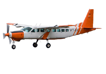
Aircraft:
Our aerial survey business unit utilizes Cessna caravan 208B modified to accommodate the optical requirements of most sensors. Standard installed equipment includes precisely surveyed GPS antenn as capable of receiving highly accurate positional signals for use in the acquisition of airborne data. Additionally, aircraft is equipped with a flightmanagement system, which provides precision navigation guidance to flight crews during data collection, as well as functionality for project management and data logging. Currently this aircraft carries Intergraph DMC II 230 large format digital mapping camera, with gyro-stabilized mount onboard, IIC provides a full workflow environment with stringent quality control. As IIC is growing rapidly, we adapt and innovate in terms of data acquisition, methodology and interoperability.
Aerial Sensor:
The DMC II230 is the industry’s most innovative turnkey large format digital frame camera system. Intergraph's digital cameras support aerial surveys for a wide range of mapping, geographic information systems (GIS), and remote sensing applications. The camera system use the industry's most precise imaging technologies. The use of solid state disks as airborne data storage increases the DMC'sreliability. The system delivers digital images enabling direct production of a wide range of mapping and image analysis products, including orthophotos, digital terrain models (DTMs), and vector maps. This combination of innovative components makes the DMC ideal for capturing data for all mapping applications, including agriculture, cadastral mapping, cartography, forestry, land use/land cover mapping, environmental studies, natural hazard assessment, flood risk management, transportation engineering, urban planning, civil engineering, oil and gas exploration, and geology.
ALS70
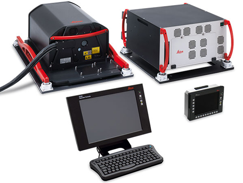
ALS70 (Airborne Laser Scanners) is a single family of systems that offers flexibility and productivity, without compromising on quality and accuracy. These Laser scanners are designed to meet the varied needs of the airborne surveys. Leica ALS70 range feature a revolutionary new system control and range measurement module. This new module significantly reduces range measurement cycle overhead, allowing pulse rates that approach the maximum theoretical limits and yielding higher pulse rates at any given altitude. In addition, this same measurement technology makes the proven MPiA feature even easier to use.
Flight Planning:
We have the ability to perform 3D photo flight mission planning and reporting. From creating initial flight plans to generating reports and indices for the final exposures. The planning system addresses functions such as flying a particular azimuth, planning the most efficient mission for area of interest, 3D mission planning, and more. Available Digital terrain model of the area will be used while performing flight planning to maintain the resolution (GSD) and avoid gaps in the overlap that are caused due to terrain variance.
ZI Inflight:
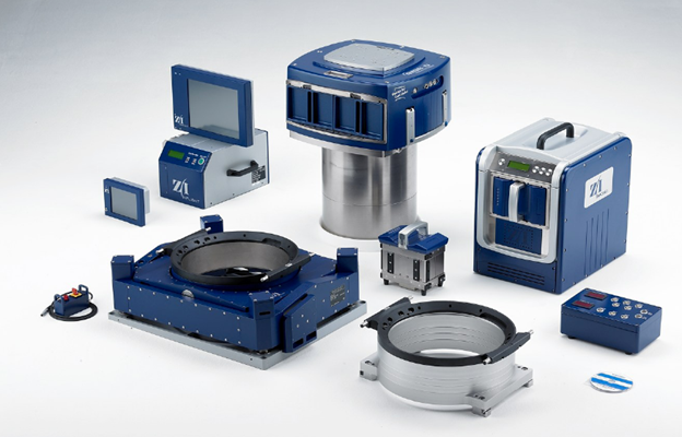
Z/I Inflight streamlines the photo flight operation and introduces a new level of automation for the complete airborne workflow. Z/I Inflight combines the power of a flight management system with selectable sensor control modules for improving efficiency in photo flights. Z/I Inflight allows Operator to interface with the DMC. The product supports a variety of peripherals, such as the Z/I Mount, gyro-stabilized camera mount, global positioning system (GPS) receivers, and inertial measurement units (IMU) systems for direct geo-referencing. Z/I Inflight simplifies aircraft installation by integrating several peripheral devices into one ruggedized hardware cabinet with small form factor, while reducing the number of units and cables in the aircraft.
Increased Performance:
Our DMC II230 is a high-performance digital camera system. It has a 1.7 second framerate to maintain high-air speed for high-forward overlap and high resolution (at 80 percent forward overlap and 6 centimeter [cm] ground sample distance [GSD], maximum air speed is 198 knots). The PAN/color ratio of 1:2.6 provides high-radiometric quality images for RGB and color infrared (CIR). The long focal length and small pixel size delivers high-resolution image data 15 cm (6 inch) GSD at 8085 feet (2464 meters)above ground level. A strong base-to-height ratio of 0.35 provides excellent stereo measurement accuracy. The nadir-looking monolithic PAN camera offers unmatched radiometric and geometric quality.
Experience:
Being the only company to own a survey aircraft and a large format digital camera in India, we have gained a wealth of experience working with the many variables that affect an aerial survey mission. We are experts at translating client’s technical requirements into efficient aerial survey mission plans, and then executing those missions with precision.
In planning and completing airborne operations, we consider seasonal and daily weather patterns, terrain, and controlled airspace factors. We have experience operating in many challenging environments and know how to work effectively with air traffic control to gain access to restricted or high-density airspace.
Beyond the aerial survey mission, our expertise includes all necessary supporting funcions, such as post-mission data processing and project management to closely monitor progress and compliance within your specifications.
Charter Services:
IIC aircraft are available for charter services within India. We are committed to give our valuable customers a unique and memorable flying experience.
Aircraft Details:
- Cessna Grand Caravan 208B
- Capacity of 09 passengers plus 02 Crew
- Fitted with Reliable Pratt&Whitney Turbine Engine with 675 HP
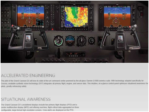
- Equippedwith Garmin 1000, Glass cockpit
- Max Cruising Speed of 184Kts (338 KPH)
- Max Range 907 NM with 45 Min Reserve at 10,000 feet AMSL
- Capable of landing and take-off from Short Runways
- Aircraft widely used as Regional Commuter Airline
Organogram
Contact Us
REGISTERED OFFICE:
6-3-250/5/B-22, Road No 1,
Banjara Hills, Hyderbad, 500034,
Andhra Pradesh, India.
+91-9177044457
Email: vijay.madhavarapu@iictechnologies.com
OPERATION'S OFFICE:
8-2-350/5/B-22, Road No 3,
Banjara Hills, Hyderbad, 500034,
Andhra Pradesh, India.
+91 40 3914 4444
Working hours:
9.30-17.30 IST